


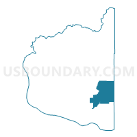
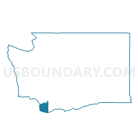
Voting District 930, Clark County, Washington
About
Outline

Summary
| Unique Area Identifier | 683940 |
| Name | Voting District 930 |
| County | Clark County |
| State | Washington |
| Area (square miles) | 34.79 |
| Land Area (square miles) | 34.79 |
| Water Area (square miles) | 0.00 |
| % of Land Area | 100.00 |
| % of Water Area | 0.00 |
| Latitude of the Internal Point | 45.69993610 |
| Longtitude of the Internal Point | -122.30904550 |
Maps

Graphs
Select a template below for downloading or customizing gragh for Voting District 930, Clark County, Washington


Neighbors
Neighoring Voting District (by Name) Neighboring Voting District on the Map
- Voting District 605, Clark County, WA
- Voting District 606, Clark County, WA
- Voting District 613, Clark County, WA
- Voting District 618, Clark County, WA
- Voting District 625, Clark County, WA
- Voting District 920, Clark County, WA
- Voting District 940, Clark County, WA
- Voting District 947, Clark County, WA
- Skye Voting District, Skamania County, WA
Top 10 Neighboring County Subdivision (by Population) Neighboring County Subdivision on the Map
- Battle Ground CCD, Clark County, WA (55,734)
- Camas CCD, Clark County, WA (52,692)
- North Bonneville CCD, Skamania County, WA (4,264)
- North Skamania CCD, Skamania County, WA (98)
Top 10 Neighboring Place (by Population) Neighboring Place on the Map
Top 10 Neighboring Unified School District (by Population) Neighboring Unified School District on the Map
- Battle Ground School District, WA (65,182)
- Camas School District, WA (28,306)
- Washougal School District, WA (19,168)
- Hockinson School District, WA (8,710)
Top 10 Neighboring State Legislative District Lower Chamber (by Population) Neighboring State Legislative District Lower Chamber on the Map
Top 10 Neighboring State Legislative District Upper Chamber (by Population) Neighboring State Legislative District Upper Chamber on the Map
Top 10 Neighboring 111th Congressional District (by Population) Neighboring 111th Congressional District on the Map
Top 10 Neighboring Census Tract (by Population) Neighboring Census Tract on the Map
- Census Tract 405.04, Clark County, WA (4,883)
- Census Tract 406.03, Clark County, WA (4,683)
- Census Tract 9502, Skamania County, WA (4,264)
- Census Tract 405.11, Clark County, WA (2,188)
- Census Tract 9501, Skamania County, WA (98)
Top 10 Neighboring 5-Digit ZIP Code Tabulation Area (by Population) Neighboring 5-Digit ZIP Code Tabulation Area on the Map
- 98682, WA (52,893)
- 98607, WA (27,899)
- 98671, WA (21,220)
- 98606, WA (9,027)
- 98675, WA (6,713)
- 98610, WA (2,871)